
Walk Chalmette Streets by Address
Begin a Chalmette street directory search with one complete address, not a person's name. The St. Bernard Parish Assessor property search links the street number to a parcel, owner, physical address, mailing address, legal description, and deed references. Those fields establish the property trail. They do not create a full household list. The official GIS map then supplies the block context, while the voter portal and historical directories provide narrower signs that a person used the address.
- Enter the number and street name in Property Address mode. Save the parcel number, physical address, owner, and legal description.
- Open the parish GIS Property Viewer. Pan along the block and compare mapped parcel shapes and street labels.
- Use Louisiana's voter Address Search for that exact address. Treat the result as registered-voter evidence, not a list of all occupants.
- Copy deed book and page references from the parcel card. Request the recorded images through Clerk eSearch or at the Clerk's office.
- For past names, check reverse telephone directories and local-history files. Keep each publication year beside the name it reports.
This order saves time because the free parcel card supplies the stable identifier needed by later sources. A street label can change, but a lot, block, subdivision, or metes-and-bounds description can still connect the same land. Record the source date at every step. Current ownership, a deed recording date, and a directory publication year answer different questions.
Search Chalmette Streets by Address
The live Assessor portal has six modes: Parcel#, Owner Name, Property Address, Section/Township/Range, Subdivision, and Legal Description. Property Address mode splits the query into Address Number and Street Name. The street box uses autocomplete. There is no visible whole-street export, ZIP filter, city filter, or date range, so a by-street project requires individual addresses or a map browse.
| Assessor field | How to use it | Limit |
|---|---|---|
| Address Number | Enter the current situs number | An older number may need a plat or deed bridge |
| Street Name | Use autocomplete and test RD/ROAD variants | Keep directionals and original punctuation |
| Parcel# | Carry the stable ID into GIS and requests | It identifies land, not a household |
| Physical Address | Locate the mapped parcel | It does not prove who occupies it |
| Mailing Address | See where the tax notice goes | It may name an agent or out-of-parish address |
| Legal Description | Match lot, block, subdivision, or tract | Read it with the recorded deed |
Results show Parcel#, Name, Physical Address, and a Details link. The detail card adds deed rows and ownership history. The portal is configured for the current 2026 tax year and shows no prior-year selector. That online limit does not mean older ownership records do not exist.
Subdivision mode can also help when the number is uncertain. The live list includes Chalmette Subdivision, Chalmette Vista Subdivision, Carolyn Park, Buccaneer Villa North, Cedar Lane Subdivision, and other named developments. A subdivision result still needs the correct lot or parcel. Legal Description mode accepts a partial word, which can recover a tract when a street label has changed. Owner Name mode works best with only a last name, but it shifts the search away from the street and may mix unrelated people. Save the result columns before opening Details so the search path can be repeated.
Chalmette Parcel Cards Add Context
A parcel detail can turn a plain address into a usable records request. The inspected 2026 assessment listing includes the owner and mailing address, physical address, ward, property type, legal description, assessed and market-value fields, homestead data, deed rows, ownership history, and subdivision or tract fields. Values are for tax purposes, not a current appraisal.
The official sample card is visible through the Assessor's parcel-details page. It shows how a Chalmette street directory result separates situs and mailing fields and places book/page clues beside deed types.
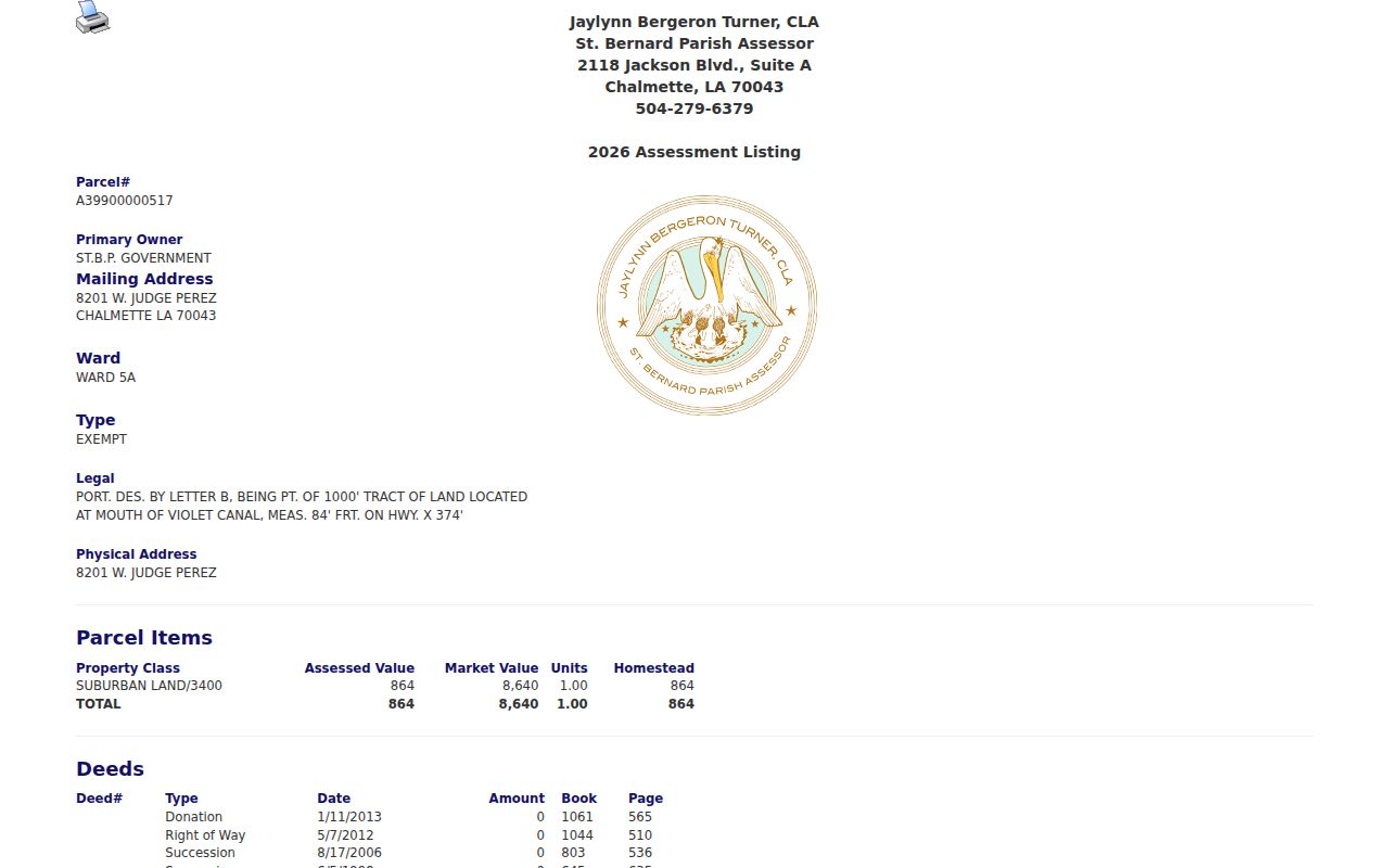
The screen is most valuable as a bridge. Copy the parcel number, legal wording, and each book/page pair before moving to Clerk records.
Fast route. Start with the free Assessor card before paying for Clerk eSearch, because the card may already supply the deed references needed for a focused request.
Map Chalmette Streets in GIS
The St. Bernard Parish GIS portal names public layers for parcels, addresses, streets, zoning, subdivisions, flood information, adjudicated property, permits, code violations, BZA cases, and zoning-compliance letters. Open the Property Viewer, pan to the street, inspect neighboring parcel polygons, and copy identifiers back into the Assessor search.
GIS is the best way to see adjacency when the Assessor accepts only one address at a time. It can also expose where one mailing address spans more than one tax parcel. Yet the parish warns that real-estate information changes through sales and re-subdivisions. The map is not title proof. Confirm owner claims against the Assessor and recorded Clerk instrument.
Note: Exact GIS popup fields and selection tools were not exposed in the research, so rely on documented map browsing rather than an assumed radius search.
Chalmette Records Indexed by Street
A useful by-address search keeps each record's claim narrow. The Assessor identifies the taxpayer and parcel. GIS shows place and layers. Deeds prove recorded transfers. Voter results cover registered voters who are not protected from display. Planning records describe property work and cases, but no researched source promises that a permit names an occupant.
| Record Set | Keeper | What It Shows | Access |
|---|---|---|---|
| Property roll | St. Bernard Assessor | Owner, mailing/physical address, parcel, deed rows | Free portal and Assessor office |
| GIS map | Parish GIS | Parcels, streets, zoning, subdivisions, public layers | Free viewer and open-data route |
| Conveyances | St. Bernard Clerk of Court | Transfers, parties, dates, book/page, legal descriptions | Subscription eSearch or courthouse request |
| Voter address result | Louisiana SOS / Registrar | Registered voters returned at an address | Free address portal; protected data withheld |
| Permit and code records | Community Development | Permits, zoning, BZA and code case links | GIS layers or parish records request |
The parcel number binds the map, tax roll, and property request. Book/page binds the Assessor card to the recorded image. The address binds those records to the voter portal and directory snapshot, but it never converts a tax owner into a confirmed resident.
Follow Chalmette Deeds by Street
The St. Bernard Clerk of Court eSearch holds the authoritative conveyance trail, but indexed records require an account and subscription. Its pre-login page does not expose the actual grantor, grantee, date, or document controls. Daily land access is listed at $20, monthly land access at $40, and displayed land images at $1 each. The exact online cutoff is not public before login.
Start with a book/page from the Assessor. Ask for the instrument image, read its grantor and grantee, then search the seller as an earlier buyer. Keep the legal description in view through every transfer. Donations, successions, rights of way, adjudications, mortgages, liens, and plats can all appear in the property trail.
- Parcel
- A tax and mapping unit with a unique assessor identifier.
- Situs address
- The physical location assigned to the parcel, distinct from the tax mailing address.
- Plat
- A recorded map that lays out lots, blocks, streets, and subdivisions.
- Criss-cross directory
- A directory arranged by street and number rather than by surname.
Check Chalmette Voters by Address
Louisiana's public Voter Portal Address Search accepts ZIP, address, optional apartment or lot, and city. The official notice says it returns voters at an address. This is the closest direct address-to-person source in the street directory, but it includes only registered voters and may suppress protected registrations.
The purchased statewide voter file is a separate route. It contains residence and mailing components and can be selected by parish, ward, and precinct. Louisiana restricts sensitive fields and certain protected categories. For help, contact the St. Bernard Registrar of Voters at 8201 W Judge Perez Drive or 504-278-4232. Never publish withheld fields or infer that a missing name means an empty home.
Chalmette Street Planning Records
Permits, code violations, BZA matters, and zoning-compliance letters can explain physical change along a block. Search the GIS layers first. Then send the address, parcel number, date span, and case type to Community Development or use the parish public-record request form. The form offers email, pickup, or postal delivery and lists $0.35 per electronic page and $0.70 per black-and-white page.
No accessible public permit query revealed a fixed result schema. Ask for the exact record instead of assuming a permit will identify an owner or resident. If the request belongs with the Clerk, Sheriff, or another custodian, follow the parish routing notice.
Community Development is based at the parish complex at 8201 W Judge Perez Drive and lists 504-278-4310. That office and the GIS team are distinct from the Clerk's courthouse at 1101 W St Bernard Highway. Send planning, zoning, and parish-held departmental requests to the parish route; send recorded conveyance and plat-image questions to the Clerk. A request that names the correct custodian, address, parcel, date range, and record type is easier to process than a broad demand for everything connected with a street.
Chalmette Street Names Can Shift
The Assessor's live street data contains variants such as BAYOU RD, BAYOU ROAD, and BAYOU RD. Test full and abbreviated road types, retain directional prefixes, and save the source's exact spelling. Judge Perez labels and St. Bernard Highway abbreviations also need care. A failed exact search may be a label problem, not proof that no parcel exists.
A 2025 parish archive entry documents a street-renaming petition at Stay Park Drive outside Chalmette's mailing ZIP. It does not prove a Chalmette renaming, but it shows the record path: planning agendas, ordinances, surveys, GIS street layers, Clerk plats, and USPS verification. No complete official Chalmette renaming list was found.
Note: Preserve the original address beside any normalized version, plus the parcel and legal description that survive many street-label changes.
Older Chalmette Streets in Print
A reverse or criss-cross directory lets a researcher move from address to a printed name. The Louisiana State Museum catalog lists St. Bernard telephone directories labeled 2003-2004, 2005-2006, 2006-2007, and 2007-2008. Requesting the actual RG 514 items is necessary because the online catalog does not show page-level entries.
Nunez Community College Archives adds maps, historic-home files, clippings, oral histories, and a Frank Fernandez index of more than 50,000 entries. Use those holdings when a current street number does not line up with an older publication. For the collections themselves, consult the Chalmette city directory page.
Limits of Chalmette Street Records
A Chalmette street directory cannot name every person who sleeps, receives mail, or spends time at an address. The Assessor centers on ownership and taxation. A deed centers on title. Voter results omit people who are not registered and may hide protected addresses. Driver and motor-vehicle address data is restricted, and no researched official utility roster provides a public household list.
Commercial neighbor tools can merge stale sources and turn former occupants into current ones. Official rolls are narrower, but their dates and custodians are visible. Confirm a name in at least two compatible records and do not force a match when the sources stop.
Lawful use. Chalmette address records support family history, property research, and civic curiosity. Never use them to stalk, harass, intimidate, or harm a person.